Proptech & Digital Survey
Technology that shapes smart, more responsive spaces.
PropTech is the bridge between design and future - a tool to deliver cutting-edge solutions for real estate.
We combine research, development and design to create more efficient processes and results. We implement PropTech technologies to enable data-driven design, shaping spaces that are efficient, innovative and able to meet increasingly specific needs.
Design phases are automated through digital tools and spatial analysis, and construction sites are monitored in real time, ensuring continuity, precision and control throughout the project lifecycle. Our approach places digitalisation at the service of sustainability, usability, and the value of real estate assets.
Analysis of pedestrian flows and behaviour simulation to support the planning of accessible and socially inclusive urban and architectural layouts.
Analysis of pedestrian flows and behaviour simulation to support the planning of accessible and socially inclusive urban and architectural layouts.
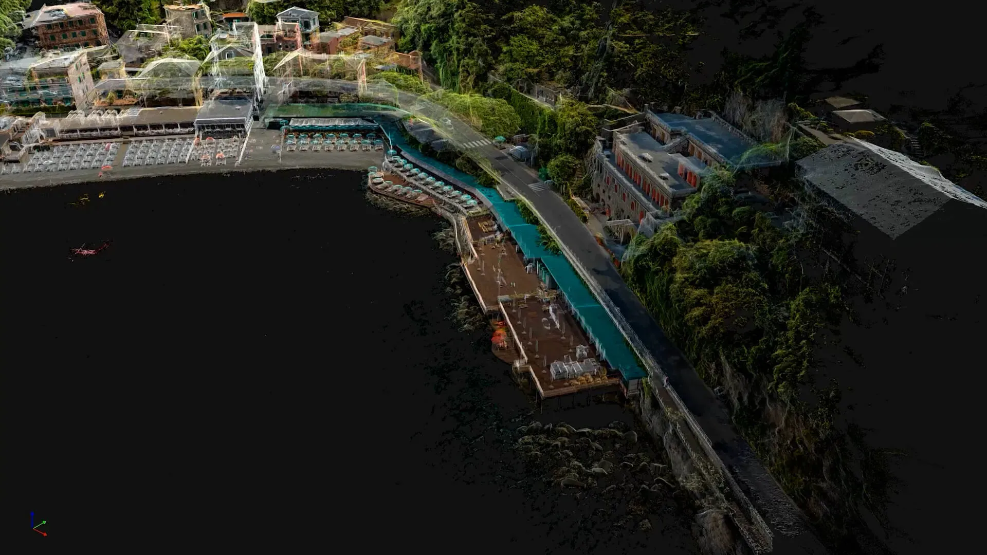
Preservation, design and institutional collaboration. 3D surveys for digital models and historical archives, benefiting public authorities and heritage agencies in the enhancement of cultural assets.
Preservation, design and institutional collaboration.
3D surveys for digital models and historical archives, benefiting public authorities and heritage agencies in the enhancement of cultural assets.
We create Digital Twins of buildings and infrastructures for dynamic performance monitoring. The integration of IoT sensors and real-time data enables smart management throughout the lifecycle of assets.
We create Digital Twins of buildings and infrastructures for dynamic performance monitoring. The integration of IoT sensors and real-time data enables smart management throughout the lifecycle of assets.
3D digital modelling integrated with processes, digital tools and strategies to organise, share and securely store all project information, ensuring traceability, accessibility and up-to-date data.
3D digital modelling integrated with processes, digital tools and strategies to organise, share and securely store all project information, ensuring traceability, accessibility and up-to-date data.
Advanced surveys (Laser Scanning, RTK/PPK/LIDAR drones, GNSS) and GIS integration deliver a detailed 3D view of the territory. DTM/DSM, georeferenced orthophotos, and overlays with cadastral and institutional data help to reduce technical and legal uncertainties and to support planning, design, and environmental monitoring.
Advanced surveys (Laser Scanning, RTK/PPK/LIDAR drones, GNSS) and GIS integration deliver a detailed 3D view of the territory. DTM/DSM, georeferenced orthophotos, and overlays with cadastral and institutional data help to reduce technical and legal uncertainties and to support planning, design, and environmental monitoring.

DO YOU WANT TO KNOW OUR POINT OF VIEW?